

23 February, 2026
There are so many uniquely beautiful things about each region of Japan. But being an island nation at the intersection of multiple tectonic plates, where over 2,000 active faults lie, makes it highly disaster-prone. Japan is vulnerable to many natural hazards: earthquakes, tsunamis, typhoons, heavy rainfall & floods, landslides, volcanic eruptions, and even snow issues in the north. Situated along the Pacific Ring of Fire, the country endures thousands of earthquakes annually. This includes devastating ones like the 2011 Tohoku earthquake and tsunami that killed nearly 20,000 people.
This concentration of multiple disaster types (seismic, meteorological, and volcanic) occurring with such regularity makes Japan one of the most disaster-prone nations globally, requiring extensive preparedness infrastructure and building codes that are among the world’s strictest.
With ongoing environmental changes, it’s important to understand what kind of challenges you might face here. The good news is that planning and preparation go very far. And while some disasters can result in fatalities, most people will survive. A lot of the risks that influence survival are within your control. So we’re here to help guide you to the information you need to plan around the risk, especially as you decide where you want to live in Japan.
The thing about natural disasters is that people tend to believe that it won’t happen to them. And that may well be true in your home country, but because Japan is so susceptible to nature’s forces, it’s not a question of if, it’s a matter of when. This could mean your family home, business assets, and your life. Don’t lose it all in one go. Proactive planning is essential, and the best planning for expats starts before you decide where you will land.

👉 This high-resolution map is available to Japan Remotely Academy members.
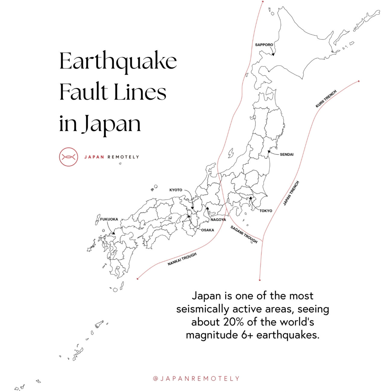
Earthquakes in Japan are different from many other parts of the world because the country sits at the intersection of major tectonic plates: the Pacific, Philippine Sea, Eurasian, and North American plates. This makes Japan one of the most seismically active regions on Earth. The constant movement and interaction of these plates (especially subduction, where one plate is forced under another) cause frequent and sometimes powerful earthquakes.
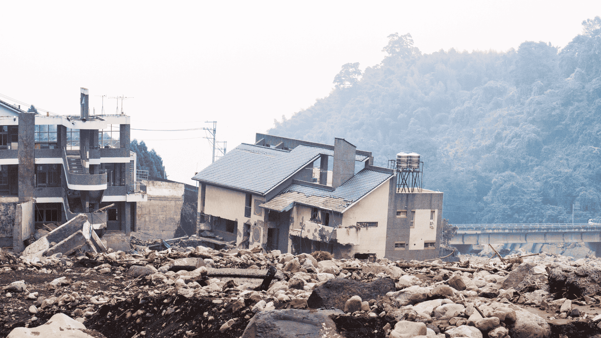
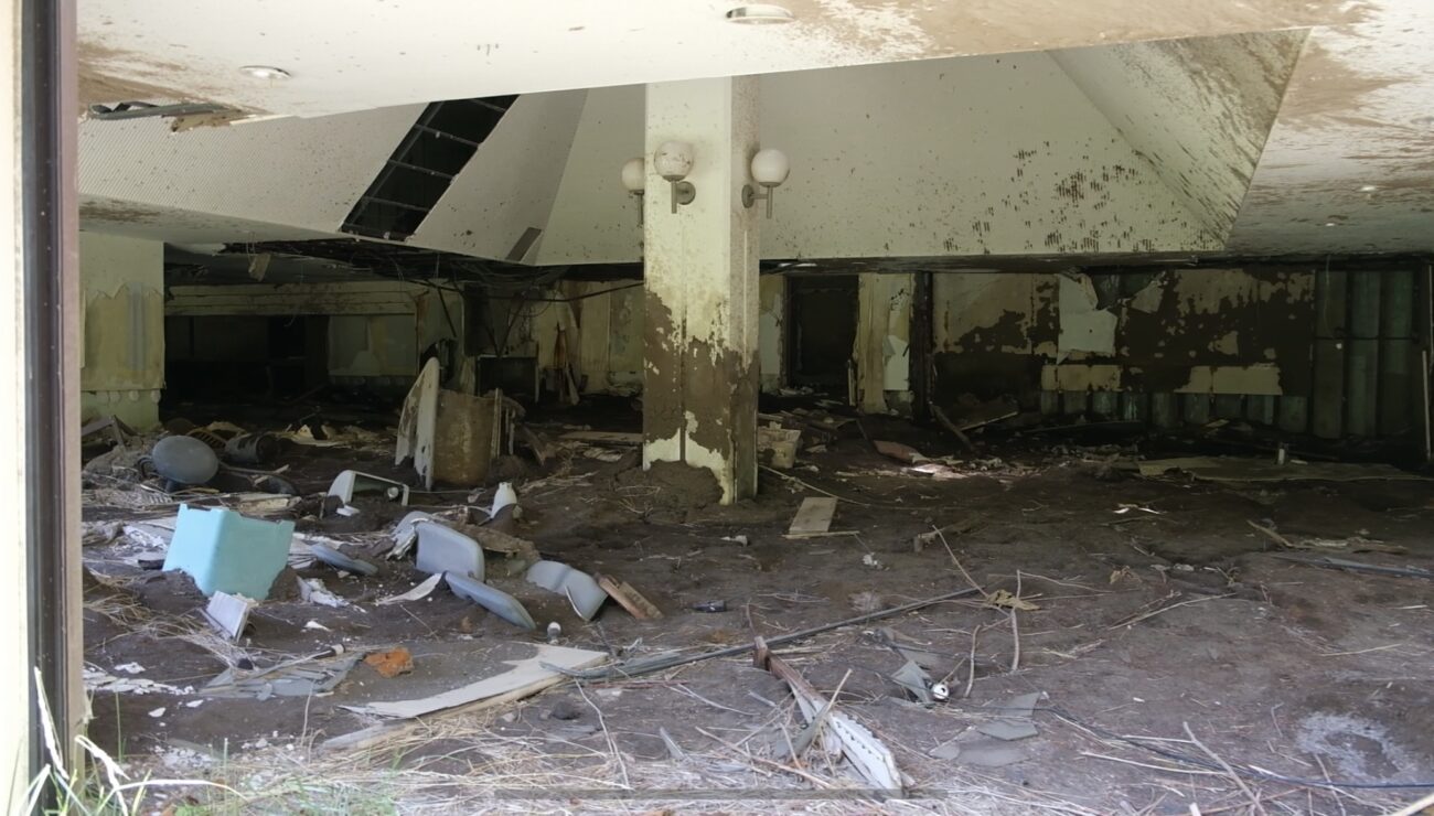
On January 1, 2024, a powerful magnitude 7.6 earthquake struck Japan’s Noto Peninsula in Ishikawa Prefecture, triggering widespread destruction across the region. The quake, one of the most intense in recent memory, caused severe ground shaking, coastal uplift of up to 4 meters, landslides, and a small tsunami. Infrastructure collapsed under the force: tens of thousands lost access to electricity and water, roads were blocked, and emergency services struggled to reach isolated areas. About 100,000 buildings were damaged or destroyed, and many residents, especially elderly individuals, were forced into evacuation shelters during the cold winter months.
It’s hard to say what is more devastating: the initial shock or lack of rebound. In a country known to build things back better, Noto simply hasn’t seen the same bounce back.
Already grappling with depopulation and an aging population, many were displaced and residents moved away. Traditional industries, like Wajima lacquerware and coastal fishing, suffered both physical damage and labor shortages. Estimated economic losses range between $7.4 and $17.6 billion, with recovery efforts ongoing and not yet complete.
👉 Watch: The Day Japan Fears The Most: $1 Trillion Megaquake (YouTube)
Hi! Are you planning your move to Japan? It’s stressful and confusing!
That’s why we made Japan Remotely Academy.
It’s years of hard-learned lessons, condensed into an easy-to-follow library of resources: how to get better jobs, find the best places to live, find foreigner-friendly housing and employment, and more! So you can move to Japan the best way for you (and the best way for Japan!) the first time around!
Location:
Off the southern coast of Japan, from Shikoku to the Tokai region.
Geological History:
Potential Impact:
Location:
Off the northeastern coast of Honshu, extending from the Boso Peninsula to Hokkaido.
Geological History:
Potential Impact:
Location:
Off the eastern coast of Hokkaido and the Kuril Islands, extending to the Kamchatka Peninsula.
Geological History:
Potential Impact:
👉 Watch: How to Survive an Earthquake (NHK)
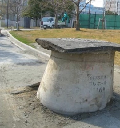
When saturated soil loses strength during an earthquake, it can cause liquefaction. As seismic waves shake loose, sandy ground with high groundwater, soil particles separate and suspend in water, turning stable land into something like quicksand. The result: buildings sink or tilt, buried structures float upward, the ground cracks, roads buckle, and water and sand shifts upward.
For anyone planning relocation in Japan, liquefaction risk is one of the most predictable and avoidable earthquake-related hazards. Unlike shaking intensity, which can strike anywhere, liquefaction depends on specific soil conditions identifiable in advance. High-risk zones include reclaimed land, old riverbeds, coastal plains, filled valleys, and other areas built on loose, waterlogged sand.
Because Japan’s cities grew through centuries of coastal reclamation, many of the most desirable urban districts including Tokyo Bay, Osaka, Nagoya, Fukuoka, and Sendai sit atop precisely the soils most prone to liquefaction. Millions live and work in zones where the ground itself can momentarily turn to liquid.
The immediate risk of liquefaction is personal harm related to collapsing buildings and infrastructure. Next, property damage, disruption to utilities and transportation, stigmatized status for property resale, and insurance complications are related to liquefaction.
But unlike some earthquake hazards that affect all locations equally, liquefaction is avoidable through careful location selection. Understanding liquefaction risk is therefore especially essential for anyone making long-term real estate decisions in Japan’s urban coastal areas.
👉 Watch liquefaction in action: 2011 Japan Liquefaction Compilation (YouTube)
The 2011 Great East Japan Earthquake caused Japan’s worst-ever liquefaction damage, especially across the reclaimed lands of Tokyo Bay. While headlines focused on the Tohoku tsunami and nuclear crisis, liquefaction quietly tore up neighborhoods hundreds of kilometers away, proving that soil conditions can matter more than distance from an earthquake epicenter.
In Chiba’s Urayasu (home to Tokyo Disneyland) nearly 85% of the city sits on reclaimed sand. When the quake struck, that sandy fill liquefied across 42% of the area. Sand and water burst from the ground, buckling streets and raising manholes half a meter. Sidewalks rippled, and apartment buildings sank or tilted despite showing no structural cracks. Thousands of homes separated from their foundations.
Infrastructure collapsed. Over 1,200 water pipes broke, cutting service to 21,000 households for up to two weeks. Gas lines ruptured, sewage failed, and buried utilities tore apart as the soil shifted in multiple directions. More than 8,000 residents moved to temporary housing.
Recovery took years. Many homeowners faced ruin. Repairs could run ¥10 to 20 million, or homes were too damaged to sell or insure. Property values in affected districts fell 30 to 50%, and mortgage lenders pulled back. Even after rebuilding, Urayasu’s liquefaction scars left a lasting stigma on once may have been considered desirable waterfront neighborhoods.
Regardless of location, these land types show elevated liquefaction risk:
Conversely, areas on bedrock, well-compacted “diluvial terraces” (台地, daichi), and hills show minimal liquefaction risk regardless of earthquake intensity.
The Tokyo Bay Area contains Japan’s highest concentration of liquefaction-prone land. In Chiba Prefecture, Urayasu City is one of the most vulnerable areas. Nearby, Chiba City’s Mihama Ward is built entirely on reclaimed land along Tokyo Bay, while the coastal zones of Narashino, Funabashi, and Ichikawa combine reclaimed ground with older alluvial (river sediment) plains, both susceptible to liquefaction.
Across the bay in Tokyo, much of Koto Ward south of the Arakawa River consists of reclaimed land and former wetlands, including the high-profile redevelopment areas of Toyosu, Ariake, and Odaiba. Parts of Edogawa Ward lie on the low-lying delta where the Arakawa River meets the bay, while Sumida and Katsushika Wards are also at risk due to their alluvial soils along the riverbanks. Even the waterfront sections of Minato Ward, including Shibaura and Daiba, sit on reclaimed ground.
In Kanagawa Prefecture, both Yokohama and Kawasaki contain extensive reclaimed and filled land. Yokohama’s Kanazawa Ward, parts of Naka Ward, and Tsurumi Ward include industrial waterfronts built on soft, saturated soils. Kawasaki’s coastal industrial and residential zones face similar risks.
The Osaka Bay Area presents another concentration of liquefaction hazards. In Osaka City, Konohana Ward (home to Universal Studios Japan) along with Nishi, Minato, Suminoe, and Taisho Wards, are all built on reclaimed or alluvial land. Even Osaka’s historical core shows moderate risk, as many former river channels and wetlands were filled centuries ago. In Kobe, the artificial Port Island and Rokko Island suffered severe liquefaction during the 1995 Great Hanshin Earthquake, and the city’s Higashinada and Nada Wards remain vulnerable. Nearby, Amagasaki and Nishinomiya in Hyogo Prefecture also contain high-risk industrial waterfront zones.
Around Nagoya, liquefaction hazards are concentrated in Minato Ward, where much of the port district sits on reclaimed land. The western parts of Nagoya City rest on the Kiso River delta, and areas near the Shonai, Shin, and Horikawa Rivers also show elevated risk. Coastal industrial areas in Tokai and Chita within Aichi Prefecture share similar vulnerabilities.Other major cities across Japan also face liquefaction threats. In Sendai (Miyagi Prefecture), reclaimed and low-lying coastal areas along Sendai Bay (especially Miyagino Ward) liquefied extensively in 2011. Niigata has a long history of liquefaction disasters, including the 1964 Niigata earthquake, which was Japan’s first major modern example; risk remains high near the Shinano River and coastal zones. In Fukuoka, reclaimed areas around Hakata Bay, particularly in Higashi Ward and Chuo Ward, are at risk. Sapporo’s Toyohira River alluvial fan and filled land also show moderate to high vulnerability, while Hiroshima faces risks across its river delta and reclaimed bayfront. In Shikoku, the coastal plains of Kochi and Tokushima are especially exposed, compounded by the region’s high earthquake potential along the Nankai Trough.
Planning your location of residence in advance is the #1 most effective way to avoid liquefaction risk. Construction type and structural updates won’t stop an entire home from sinking into the ground.
If you want to avoid liquefaction risk, avoid coastal, riverside, or former wet areas, especially those developed using reclaimed sand. As always, reference local hazard maps or the nation-wide liquefaction history map from the National Research Institute for Earth Science and Disaster Resilience. Consider the example of Urayasu’s 2011 damage. The hazard maps accurately predicted which neighborhoods would liquefy. Reclaimed land areas showed high risk, while the small section of original coastline showed low risk. The actual liquefaction damage matched these predictions very closely.
Example: Liquefaction Risk Map of Tokyo Bay
If a local liquefaction map is difficult to find, try searching for “[location name] は液状化の危険性があるか?” – meaning “Is there liquefaction risk in [location name]?” and do your best with browser translation tools.
You can visit the local government office for information on specific addresses and updates on any ground improvement projects. Professional soil assessments are possible, however cost-prohibitive. Some municipalities such as Tokyo offer surveying assistance. If your prospective residence location is adjacent to known risk areas, your property will still be affected by utility disruptions and stigma in the case of a liquefaction event.
Japan is at one of the most volcanically active countries in the world. The archipelago contains approximately 111 active volcanoes – roughly 10% of all active volcanoes globally.
While you may imagine the worst part of a volcano eruption to be bursting lava, that’s not the full risk posed by volcanoes. Larger-spanning volcanic disruption comes from ash emissions that can disrupt air, rail and car travel, contaminate water supplies, destroy infrastructure, cut off utility and lifelines, and force mass evacuations.
Regarding volcanic ash fall, even less than 0.1mm is noticeable. It can stick to your body and clothes, and the fine particles can cause eye and respiratory irritation. Aircraft operation will be suspended, as there is risk of engine failure. From 0.1 to 1mm of ash, it is difficult to see lines on the road, and you should definitely wear a mask. Trains may be halted. At 1mm or more, the roads are completely covered, and there will be power, water, and utility disruptions. 10cms will make it impossible for cars to navigate. At 30cm if ash is combined with rain, wooded houses may collapse from the weight.
👉 Watch: Impacts of a Major Eruption of Mt. Fuji and Wide-Area Ash Fall (Disaster Management,Cabinet Office)
Mount Usu and Mount Kompira in Hokkaido erupted in March of 2000. Due to the preparation of local residents, luckily there were no deaths. But 234 homes were destroyed and another 217 homes saw damage. (source) During eruption, dozens of craters were spewed into the air, scattering across the landscape.
Hot mud flowed from the volcano, picking up an entire highway bridge, carrying it 90m and crashing into public housing. The mudflow also overtook the nearby town-run hot spring facilities. These structures still stand in an area called the “Konpira Ruins,” part of the Toya-Usu UNESCO Global Geopark.
On another occasion in September of 2014, Mount Ontake erupted suddenly without significant warning. The eruption killed 63 people, most of whom were hikers. The thing about Mount Ontake is that this mountain was classified as relatively low-risk. It is a reminder that volcanoes, even “low risk” ones, could erupt at any time. This includes Mount Fuji, putting all of Tokyo at risk.
Volcanic hazard levels vary significantly across Japan. The highest-risk areas include:
Hokkaido: Mount Usu near Lake Toya, known for frequent eruptions every 20–50 years; Hokkaido-Komagatake; and the active volcanic island of Etorofu in the disputed Northern Territories.
Northern Honshu: Mount Zao on the Miyagi-Yamagata border; Mount Bandai in Fukushima; Mount Azuma; and the volcanic Hakkoda Mountains in Aomori.
Central Honshu: Mount Fuji (last erupted 1707); Mount Asama on the Nagano-Gunma border; Mount Ontake; and the volcanic caldera surrounding Hakone near Tokyo.
Kyushu: This southern island contains the highest concentration of active volcanoes in Japan. Sakurajima near Kagoshima erupts hundreds of times annually. Mount Aso hosts one of the world’s largest volcanic calderas with an active central crater. Kirishima volcanic group regularly shows activity. Unzen volcano, site of a devastating 1991 eruption that killed 43 people.
Remote volcanic islands: The Izu Islands south of Tokyo, including Miyakejima (forced complete evacuation 2000-2005); Nishinoshima, which has been actively growing through eruptions; and various uninhabited volcanic islands in the Ogasawara chain.
Areas within 10-15 kilometers of active volcanic craters face the highest risk from flow and projectiles. However, ashfall hazard zones can extend 100+ kilometers downwind. For example, Tokyo and other major cities are within potential ashfall zones from Mount Fuji, and volcanic ash from Kyushu eruptions can affect even parts of western Honshu with certain wind conditions.
A detailed volcanic hazard map showing Japan’s 111 active volcanoes and their alert zones is available through the Japan Meteorological Agency (JMA). The agency classifies volcanoes into five alert levels, with Level 2 or higher indicating areas where access restrictions are in place. The JMA website maintains volcani alert level ratings on the interactive map.
Additionally, participate in local emergency preparedness drills, keep emergency notification apps installed on your phone, keep at least half a tank of gas in your car if you have one, and consider power backups for critical equipment.
Technically nuclear emergencies aren’t a “natural” disaster, however they can be spurred or worsened by earthquake, tsunami, flooding, etc. When it comes to disaster planning in Japan, it is a necessary consideration. Japan operates 33 nuclear reactors across 18 power plant sites, though not all are currently active following post-Fukushima safety reviews. Nuclear power plants pose unique risks, including radiation exposure from accidents, the psychological and economic impacts of evacuation zones, and long-term contamination concerns that can render areas uninhabitable for decades.
Nuclear disasters happen when a nuclear power facility release radioactive materials. A radioactive plume will spread downwind, which can cause exposure to the body both externally and from inhalation, and affects crops and animals. This kind of disaster is unique in that radiation cannot be sensed through sight, taste, hearing, etc. It’s a quiet disaster.
For relocation planning, proximity to nuclear facilities matters because accidents (while statistically rare) can have catastrophic and generations-long consequences. The Fukushima Daiichi disaster demonstrated that even in a technologically advanced nation with strict safety protocols, the combination of natural disasters and equipment failures can trigger nuclear emergencies.
Areas within 30 kilometers of nuclear plants are designated as Emergency Planning Zones (EPZ), where residents must maintain evacuation plans and may face restrictions on agriculture, fishing, and property development.
The Fukushima Daiichi nuclear disaster, triggered by the March 11, 2011 Great East Japan Earthquake and tsunami, remains the world’s worst nuclear accident since Chernobyl. It fundamentally reshaped Japan’s relationship with nuclear power. The magnitude 9.0 earthquake automatically shut down the three operating reactors at the coastal Fukushima Daiichi plant, but the 15-meter tsunami that followed overwhelmed the facility’s 10-meter seawall, flooding the lower grounds and disabling backup generators critical for cooling the reactor cores.
Over the following days, three reactors experienced core meltdowns. Explosions damaged reactor buildings and released radioactive materials into the environment. Approximately 154,000 residents were evacuated from areas surrounding the plant, with some evacuation orders expanding to a 30-kilometer radius. The Japanese government initially established a 20-kilometer exclusion zone, and later expanded it based on radiation measurements rather than distance alone.
The human toll extended far beyond radiation exposure. The chaotic evacuation itself caused approximately 2,000 deaths among elderly and hospitalized patients who died from stress, exhausted immune systems, and inadequate care during relocation. Entire communities were dissolved overnight. The town of Futaba, located adjacent to the plant, saw its population drop from 7,000 to zero, with residents scattered across Japan. Over a decade later, many formerly evacuated zones remain partially or fully uninhabitable, with some areas projected to be unsafe for 30-40 years.
Economic damage estimates are around $200 billion, including cleanup costs, compensation payments, lost property value, and agricultural losses. Fukushima Prefecture’s fishing and farming industries were devastated by contamination concerns that persist today. The disaster triggered a nationwide shutdown of all nuclear reactors and sparked fierce debate about Japan’s energy future.
Critically for relocation planning, Fukushima demonstrated that nuclear accidents create permanent geographic consequences. The “difficult-to-return zones” around the plant may never fully recover their pre-disaster populations or property values, even as radiation levels gradually decline. Former residents face an impossible choice: return to decontaminated but psychologically scarred communities with limited services and few neighbors, or permanently abandon home and land.
Nuclear power plants requiring consideration in relocation planning are distributed across Japan’s coastline, with concentrations in certain regions:
Hokkaido:
Northern Honshu (Tohoku):
Central Honshu (Chubu/Hokuriku):
Kansai region:
Fukui Prefecture hosts the highest concentration of nuclear reactors in Japan, earning the nickname “nuclear ginza.” The region supplies significant power to Osaka, Kyoto, and other Kansai cities despite being located 100+ kilometers away.
Western Honshu (Chugoku):
Shikoku:
Kyushu:
Location planning is key. The 30-kilometer Emergency Planning Zones (EPZ) surrounding each facility represent areas where residents should maintain evacuation plans and expect potential restrictions during emergencies. However, Fukushima demonstrated that dangerous radiation levels can extend beyond these zones depending on weather patterns and topography. The 50-kilometer radius provides a more conservative safety buffer for risk-averse individuals.
Consider that:
For those accepting moderate proximity to nuclear facilities, prioritize:
Real estate disclosure laws require agents to inform buyers about proximity to nuclear facilities and any radiation-related issues, but independently confirming this information through government sources is also advisable.
You may also wish to speak with local residents to hear how proximity has affected lives locally, however also remember that many residents may wish to avoid stating strong opinions, especially if it goes against the judgement and choices of the government. Many people in Japan have high trust in their governments. But the best decision for you is one that you fully understand and feel confident in.
Flooding represents one of the most frequent and widespread natural disaster risks in Japan, affecting both urban and rural areas throughout the country. Japan’s flood risk stems from multiple sources: river overflow during heavy rainfall, storm surge from typhoons, tsunami inundation in coastal areas, and localized urban flooding when drainage systems are overwhelmed. The country’s mountainous topography means that approximately 10% of the population lives on floodplains and low-lying areas that comprise only 2% of the land area, creating concentrated vulnerability.
For relocation planning, flood risk matters because it is both common and predictable. Unlike earthquakes, which strike without warning, flood-prone areas are well-documented through historical records and hazard mapping. Japan experiences significant flooding events almost annually, with seasonal patterns tied to the June-July rainy season (tsuyu), typhoon season (August-October), and occasionally winter snowmelt in northern regions.
Flooding poses immediate danger to life, but of course also puts personal property at risk. Higher risk locations may see higher insurance premiums, more frequent disruptions such as power outage and transportation closure, and flooded property can result in damage to property, mold, and compromised structures.
In July 2018, Western Japan saw prolonged heavy rainfall that triggered catastrophic flooding across a wide geographic area, even in regions with modern infrastructure and disaster preparedness systems. Some areas received over 1,000mm of precipitation in just 72 hours, which is rare but continues to be possible, especially with increasing occurrence of “unprecedented” environmental events associated with climate change.
The flooding killed 237 people and affected 15 prefectures, with Hiroshima, Okayama, and Ehime prefectures seeing the worst damage. In Kurashiki City, Okayama Prefecture, floodwaters reached second-story levels in many buildings. Over 4,600 residents were trapped in their homes, requiring helicopter and boat rescues. The Mabi district flood in Kurashiki saw 51 lives lost, many of them elderly residents who were unable to evacuate quickly enough.
Flooding triggered over 1,700+ landslides across the affected region, as saturated hillsides collapsed onto communities below. This combination of flooding and landslides meant that even areas not in traditional floodplains faced danger.
Despite advanced weather forecasting and evacuation orders issued hours before the worst flooding, many residents did not evacuate. This highlighted the gap between technical warning systems and human behavior, particularly in areas where serious flooding is rare enough that residents underestimate risk. Foreign residents face additional risk of misunderstanding emergency instructions.
The 2018 disaster prompted Japan to revise its flood hazard mapping standards and introduce new evacuation alert levels, but it underscored a fundamental reality: living in designated flood zones means accepting recurring, potentially life-threatening risk regardless of how modern the surrounding infrastructure appears.
Flood risk in Japan is distributed across multiple geographic settings, including urban and rural areas.
Major River Systems: Japan’s largest rivers present flood risk to surrounding floodplains:
Low-Lying Urban Areas: Major cities with significant below-sea-level or near-sea-level districts:
Western Japan Regions (particularly vulnerable during rainy season and typhoons):
Kyushu: The entire island faces elevated flood risk due to steep mountains, narrow valleys, and direct exposure to typhoon paths. Cities including Fukuoka, Kumamoto, and Kagoshima have recurring flood problems.
Hokuriku Region (Japan Sea coast): Heavy winter snowfall followed by rapid spring melting can trigger river flooding in Niigata, Toyama, and Ishikawa prefectures.
Coastal Areas Throughout Japan: All coastal regions face storm surge flooding during typhoons, especially low-lying areas without natural barriers, and enclosed bays.
Detailed flood hazard maps for every municipality in Japan are available through local government offices and online portals, often showing predicted inundation depths for various rainfall scenarios (50-year, 100-year, and 1,000-year events).
The Disaster Prevention Portal from the Ministry of Land, Infrastructure, Transport and Tourism is an extensive resource including river flooding, inundation, rainy season and typhoon risk information. There is also a list of links for every prefecture’s disaster prevention sites and a live, interactive map with flood forecasts.
👉 See also: How to Survive a Flood (NHK)
When evaluating real estate, consider the following points:
Japan Meteorological Agency – Flood Risk Information
Real-time rainfall data, flood warnings, and river water level information
MLIT River Bureau – Real-Time River Information
Live water level monitoring for major rivers throughout Japan (Japanese language)
Your municipal government website
Navigate via the Hazard Map Portal Directory, or search for “[city name] 洪水ハザードマップ” (flood hazard map) or “[city name] 防災” (disaster prevention) for area-specific flood maps, evacuation shelters, and alert registration
Typhoons are powerful tropical cyclones that form over the warm waters of the western Pacific Ocean when sea surface temperatures exceed approximately 26.5°C (80°F). When warm, moist air rises rapidly, it creates a pressure imbalance that begins to rotate, forming the characteristic spiral structure with an eye at the center. These storms bring fast, destructive winds, torrential rainfall, storm surges, and can result in flooding and landslides (which are related to oversaturated ground). While 25 to 30 typhoons may form in the Pacific each year, only about 3 to 5 touch land in Japan.
Peak typhoon season is late summer, when ocean temperatures are warmest. Okinawa and the southern islands are particularly vulnerable due to their location, though typhoons can track northward. Typhoons sometimes reach as far as Hokkaido, though they typically weaken as they move over cooler northern waters.
The danger of typhoons is primarily associated with the extreme rains and high tide. Strong winds can cause property damage, however simple interventions such as bringing belongings inside and closing storm shutters over windows will typically be ample wind preparation. Additional issues may include halted transportation or loss of power.
Typhoon Vera, known in Japan as the Isewan Typhoon, struck in September 1959 and remains the deadliest typhoon in Japanese history, killing over 5,000 people and leaving approximately 1.5 million homeless. The storm made landfall near Nagoya with catastrophic storm surges that inundated the densely populated Ise Bay area, breaching levees and flooding vast areas with little warning.
Winds exceeded 260 km/h (160 mph). The combination of high tides, heavy rainfall, and storm surge created devastating floods up to 4 meters deep in some areas. The overwhelming flooding resulted in deaths, and there were also disease outbreaks afterwards related to broken sanitary systems and overwhelmed evacuation conditions.
Today, however, Japan is far better prepared to manage typhoons. Typhoons are slow moving, their track is easy to predict, and information is easily shared through media and alert systems. Both disaster response systems and building codes have strengthened substantially since 1959. Typhoon fatalities are a much lower risk now, despite Japan continuing to face frequent and powerful storms.
The southernmost regions of Japan experience typhoons most frequently, with Okinawa and the Ryukyu Islands bearing the brunt due to their location in the tropical western Pacific directly along common typhoon tracks. Okinawa typically faces 7-8 typhoon approaches annually, with several making direct hits. Kyushu, Japan’s southernmost main island, is the second most affected region, experiencing frequent typhoon landfalls particularly along its western and southern coasts. The Pacific coast of western Japan, including areas around Shikoku and the Kii Peninsula, also sees high typhoon activity as storms curve northward along the land. Northern regions like Tohoku and Hokkaido experience fewer typhoons, and those that do reach these areas are typically weakened as they move over cooler waters, though they can still bring strong rainfall and wind.
If you would like to reduce the risk associated with typhoons, the biggest difference will be made before you decide where to live. Here is how location selection can influence typhoon risk:
When considering buying or renting a home, here are some more items to consider:
For preparations during the time of typhoon, check these tips from the Tokyo Intercultural Portal Site. Typhoon approach can be monitored on the Japan Meteorological Association website.
Heavy snowfall in Japan represents a significant natural hazard that affects millions of residents annually, particularly along the Sea of Japan coast and mountainous regions. Japan experiences some of the heaviest snowfall in the world, with certain areas receiving over 10 or even 20 meters (65 feet) of snow during a single winter season. This phenomenon occurs when cold Siberian air masses move across the relatively warm Sea of Japan, picking up moisture and depositing it as snow when they reach the Japanese archipelago.
The risk matters profoundly in Japan because heavy snowfall can cause:
Unlike sudden-onset disasters like earthquakes, heavy snowfall is a slow-moving but relentless hazard that can persist for days or weeks, creating cumulative risks that escalate as snow accumulates.
👉 Watch: Life in the World’s Snowiest City (YouTube)
In the winter of early 2026, heavy amounts of snow across Niigata, Aomori, Akita, and northern Tohoku overwhelmed daily life. Historic levels of snowfall ranged between 1.7 meters in Aomori city to 4.5 meters at Sukayu observation point. The weight of snow collapsed some buildings, and snow slipping from roofs caused risk to pedestrians and shovelers. During this time, 30 deaths and 324 injuries were reported.
Fukui Prefecture experienced its worst snowfall in 37 years, with over 140 centimeters accumulating in some areas within 48 hours. The city of Fukui recorded 147 cm of snow depth, the highest since 1981. Approximately 1,500 vehicles became trapped on National Route 8, stranding thousands of motorists for over 40 hours in freezing conditions. Some drivers were trapped for three days without adequate food, water, or heating. Over 10,000 households lost power at the peak of the storm. At least 14 deaths were attributed to the snowfall, primarily from snow removal accidents and vehicles becoming trapped. Agricultural facilities collapsed under snow weight, destroying greenhouses and killing livestock. Economic losses exceeded 100 billion yen.
The disaster revealed critical vulnerabilities in Japan’s snow response systems, including insufficient snow removal equipment in areas unaccustomed to such extreme accumulations and inadequate real-time communication systems for stranded motorists. It prompted nationwide reviews of snow disaster preparedness protocols and building standards.
Heavy snowfall risk in Japan concentrates along distinct geographical patterns:
Highest Snowfall Risk Zones:
Moderate Risk Areas:
Key Geographic Pattern: The Sea of Japan coast from Hokkaido through Tohoku to Hokuriku forms Japan’s primary “snow belt” (豪雪地帯), designated under the Special Measures Law Concerning Countermeasures for Heavy Snowfall Areas.
Comprehensive snow risk mitigation requires multiple strategies across property selection, structural design, and operational preparedness:
Building Codes and Structural Measures
Japan’s Building Standard Law establishes snow load requirements based on regional risk. In designated heavy snowfall areas, buildings must be designed to carry the weight of snow, depending on the specific zone classification. Other interventions include roof design (reinforced trusses and load-bearing walls capable of handling extreme accumulations, plus roof pitches that self-shed snow), roof heating (heating cables that prevent dangerous ice dam formation and facilitate controlled snow melting), snow guards (these prevent sudden avalanche-like slides that could injure people below), structural reinforcement (enhanced pillar and beam specifications, sometimes 1.5-2x the standard structural requirements in heavy snow zones), and regular inspections (particularly for older buildings).
Location Selection Considerations
When choosing property in snow-prone regions, it is important to look closer than citywide averages and instead evaluate historical snow depth data for the specific neighborhood. Conditions can vary greatly from one area to another, and localized data will give you a clearer picture of what to expect. Accessibility is another key factor. Homes located on steep slopes or along narrow roads may become isolated during heavy snowfall, making daily life and emergency access more difficult.
You should also check how close the property is to snow removal priority routes, such as national highways or designated emergency roads, since these are cleared first. Municipal hazard maps can help you assess whether the property is located within an avalanche risk zone. Additionally, it is wise to verify whether the municipality offers snow removal support programs, which can ease the burden of winter maintenance.
Finally, consider the orientation of the property. South-facing homes benefit from greater sunlight exposure, which encourages natural snow melting and reduces buildup around the property. Together, these factors can make a significant difference in both comfort and safety when living in areas with heavy winter snowfall.
Anticipate Additional Preparedness Tasks
Know that additional preparation will be necessary for winter in snow-prone regions. Stocking emergency supplies is a priority: aim for at least a two-week reserve of food, water, and batteries. You will likely want at least one kerosene stove on hand with fuel stores. Snow removal tools such as shovels, roof rakes, and de-icing agents should be ready and in good condition. Plan to winterize vehicles with snow tires, no-freeze windshield fluid, and equipped with emergency kits containing blankets, water, and snacks. Around the home, gutters and drainage systems require clearing and monitoring, and overhanging tree branches trimmed to reduce the risk of damage from heavy snow.
We reviewed comprehensive data from Japanese government sources (Japan Meteorological Agency, Ministry of Land, Infrastructure, Transport and Tourism) and research studies (including LIFULL HOME’S and various disaster analysis reports) to evaluate earthquake risk, fault line proximity, flood risk, tsunami vulnerability, landslide and volcanic risk, and local preparedness.
Generally speaking, inland prefectures (not ocean-adjacent) are seen as safer due to absence of tsunami risk. Areas with low population density means there are fewer cascading risks such as neighborhood fire spread. If the area has a history of lower seismic activity, this will also impact local perception of disaster risk and safety.
Here’s where we believe are the safest prefectures for natural disaster risk.
Why it’s safest:
Considerations: While overall risk is low, heavy rainfall events can still cause localized flooding, particularly in river valleys. Urban planning has improved significantly since 2018.
Why it’s safe:
Considerations: Mountain areas may have landslide risk during heavy rain. Prospective valley residents should reference local hazard maps.
Why it’s safe:
Considerations: Some areas near fault lines require attention. Southern regions closer to potential Nankai Trough impact should be evaluated carefully. Narrow valleys may experience flash floods during extreme rainfall. Limited evacuation routes in rural mountain towns could be a concern.
Why it’s safe:
Considerations: Lake Biwa areas may have localized flood risk. Overall disaster profile remains excellent.
Why it’s safe:
Considerations: Recent research indicates previously unknown active faults may exist offshore, though activation probability remains low. The GNS ranking doesn’t fully account for all seismic risks. Tottori experienced strong inland quakes in 2000 and 2016, so future events remain possible.
Why it’s safe:
Considerations: Akita experiences heavy snowfall and landslide risk in rural mountain areas. Seismic activity remains possible along nearby inland faults.
Why it’s safe:
Considerations: Coastal areas remain vulnerable to tsunamis, though defense infrastructure is extensive. Inland regions are safer overall.
Why it’s safe:
Considerations: Volcanic risk exists due to proximity to the Daisen and Sanbe volcanic zones, though activity levels are low. Flooding can occur in river valleys.
Why it’s safe:
Considerations: Some flood risk exists along the Tone River, especially in southern areas bordering Saitama. Winters can be harsh in mountainous regions.
Why it’s safe:
Considerations: Volcanic risk exists around Mount Nantai and Nikko areas. Heavy rain can trigger localized landslides.
Why it’s safe:
Considerations: Prone to heavy snow and avalanches in winter. Seismic activity possible along the Itoigawa-Shizuoka Tectonic Line on the western border.
Why it’s safe:
Considerations: Low-lying eastern areas near rivers (Arakawa, Tone) are vulnerable to flooding. Seismic shaking from Tokyo earthquakes can still reach Saitama.
No prefecture is disaster-free. Inland areas can experience earthquakes from unknown faults. Climate change is increasing extreme weather events nationwide, including extreme summer heat. Heatstroke is a major threat, especially if accompanied by power outage (affecting access to air conditioning). Local geography within each prefecture varies significantly, and some risks can vary on a localized scale block-to-block or even house-to-house in some cases, considering factors such as terrain type, slopes and construction density.
Tokyo faces significant natural disaster risks due to its location on the Pacific Ring of Fire. The city experiences seismic activity roughly every five minutes, and experts estimate a 70% probability of a major earthquake (magnitude 7 or higher) striking the southern Kanto area within the next 30 years.
Key risks in Tokyo include earthquake, tsunami (with estimated maximum inundation heights of 2-3 meters in low-lying bayside areas), flooding, particularly affecting low-lying eastern wards, liquefaction, and fire spread risk for dense neighborhoods, particularly those with wood construction buildings.
The geographic reality of Tokyo divides the city into two main zones: the elevated Yamanote plateau (western areas) with stable geology and firm ground, and the low-lying Shitamachi lowlands (eastern areas) built on former marshland or reclaimed land, which are more susceptible to flooding, liquefaction, and building damage.
The Tokyo Resilience Project is an unprecedented $100 billion initiative to protect the world’s largest metropolitan area from every conceivable disaster. It includes underground infrastructure of massive flood tunnels designed to manage water surges, advanced seismic engineering, bridge reinforcement, coastal defenses, neighborhood upgrades, and resilient networks.
Despite the massive scale and advancements of this project, the city will never be fully disaster-proof.
👉 Watch: The Insane Scale of Tokyo’s Disaster Megaplan (YouTube)
For expats and international residents considering where to live in Tokyo, certain neighborhoods offer better natural disaster safety profiles due to their elevation, solid geology, modern infrastructure, and disaster preparedness resources. Get acquainted with these areas and risk factors when planning your life in Tokyo.
Often cited as one of Tokyo’s safest wards from natural hazards. Located centrally on the high Yamanote plateau with neighborhoods like Hongo and Koishikawa
Advantages: Virtually no flood-prone areas (no large rivers running through it), elevated ground means lower liquefaction risk, firm soil reduces earthquake shaking, lower fire risk due to modern mid-rise apartments and institutional buildings rather than old wooden houses
Ideal for: Expats prioritizing overall disaster safety in central Tokyo
Why it’s recommended: Contains some of the highest ground in central Tokyo, with large portions on upland forming part of the Musashino plateau’s edge. Ranked #1 in a 2025 “disaster-resistant wards” assessment
Advantages: Stable geology with less shaking risk, very low flood and tsunami risk (only minimal flood zones near Ebisu and Meguro River), modern infrastructure with well-maintained buildings
Ideal for: Those wanting vibrant urban life with excellent disaster resilience
Why it’s recommended: Large residential ward on elevated terrain in western Tokyo
Advantages: Higher ground reduces flood risk, relatively lower building collapse risk compared to eastern wards, good access to evacuation routes and open spaces
Ideal for: Families seeking residential areas with good disaster safety
Why they’re recommended: Both are plateau wards in western Tokyo with better geological stability
Advantages: Scored well in Tokyo’s Regional Earthquake Risk Assessment, wider roads facilitate evacuation, less dense wooden housing reduces fire spread risk
Ideal for: Those seeking quieter suburban living with solid disaster safety
The eastern low-lying wards (Edogawa, Koto, Katsushika, Adachi, Sumida, and Arakawa) face multiple challenges. They sit at or below sea level, have softer alluvial soil that amplifies shaking and is prone to liquefaction, they contain concentrations of older wooden structures increasing fire risk, and show potential inundation depths of 3-5 meters in worst-case flood scenarios. While these areas are improving through urban redevelopment and have excellent disaster preparedness systems, international residents should be particularly diligent about checking hazard maps and understanding evacuation procedures.
There is no magic wand that will tell us exactly what disaster will happen when and where, however there are plenty of ways to be prepared and stay vigilant. The first step is to take some time to reflect personally on what risks you are concerned about and how discriminating you are willing to be. Use our comprehensive risk map in Japan Remotely Academy to understand the general risk traits of various prefectures across Japan. When searching for a home, take a closer look at local maps to understand more localized risks such as liquefaction, flood zones and landslide. Assess safety aspects of your potential home, including age, maintenance, termite damage, presence of storm shutters, etc. And finally, execute preventative measures within the home such as selecting furniture carefully, securing large items and maintaining access to a stable table or desk for personal protection. Keep emergency disaster supplies and an evacuation backpack up-to-date and in easy access.
The goal is to be informed and empowered. Stay safe, all!
Do you have questions about how you can make a strategy to move (and stay!) in Japan? Maybe you’ve got an area in mind, but aren’t yet sure how to make a visa and work plan?
👋 Hi! I’m Nick, an experienced Immigration and Moving Consultant at Japan Remotely. Having lived in several places across Japan, I understand the ins and outs of navigating life in Japan.
We help you navigate visa types, Japan real estate, location scouting, career opportunities in Japan, business strategy, and more. We help you create a realistic Action Plan and Visa Strategy, so you can find your fastest track to permanent residency and the lifestyle you’ve been dreaming of.
Interested to learn more? Talk to us! We are happy to discuss a custom strategy.

23 February, 2026
19 September, 2025